
Drones in Agriculture
Thank you for your interest in Corvus Aerial Imaging, where we provide you with data you can use to take your operation to the next level using our cutting-edge crop survey analysis technology. We provide NDVI, NDRE, RGB, and a variety of other indices that you can use to ensure the maximum return on your investment.

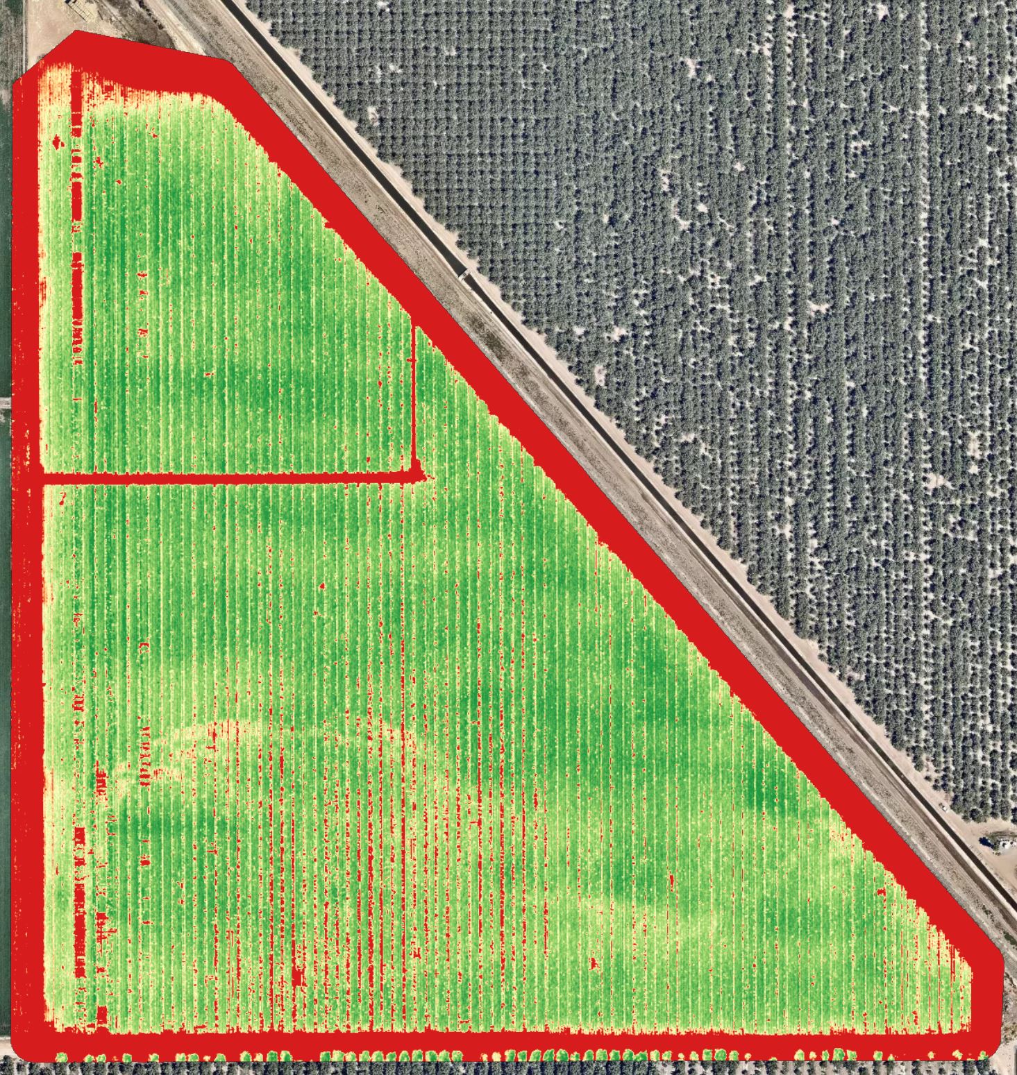
For more than 40 years, agronomists and scientists have used Normalized Difference Vegetation Index (NDVI) to assess the health of crops and plants. NDVI was created when scientists learned that a plant’s unique reflection of a combination of visible red light and near-infrared (NIR) light gave a good indication of plant health — far superior to what the reflectance of visible light can reveal. Simply put, NDVI is a single measure that characterizes this information. In precision agriculture, NDVI data provides growers with an accurate measurement of crop vigor and allows them to zero in on problem areas that may need further attention. NDVI is a great general indicator of crop health, and now with drone platforms, NDVI measurements can take advantage of high-resolution imaging to establish measurements during earlier growth stages that were only possible, or economically feasible, with satellite or manned aircraft.
What is NDRE?
NDRE is an index that can only be formulated when the Red edge band is available in a sensor. It is sensitive to chlorophyll content in leaves (how green a leaf appears), variability in leaf area, and soil background effects. High values of NDRE represent higher levels of leaf chlorophyll content than lower values. Soil typically has the lowest values, unhealthy plants have intermediate values, and healthy plants have the highest values.
Consider using NDRE if you are interested in mapping variability in fertilizer requirements or foliar Nitrogen, not necessarily Nitrogen availability in the soil. NDRE is a better indicator of vegetation health/vigor than NDVI for mid to late season crops that have accumulated high levels of chlorophyll in their leaves because red-edge light is more translucent to leaves than red light, and so, it is less likely to be completely absorbed by a canopy.
What is the difference between NDVI and NDRE?
The visual-band red content that is used in NDVI is absorbed strongly by the top of the plant canopy. This means that lower levels of the canopy don’t contribute much to an NDVI measurement. This impairs correlation of NDVI to things like leaf area index (LAI). This effect increases in plants with more layers of leaves, like tree canopies or later-stage corn.
Substitution of NDVI’s red band with NDRE’s red edge band provides a measurement that is not as strongly absorbed by just the topmost layers of leaves. NDRE can give better insight into permanent or later stage crops because it’s able to measure further down into the canopy.
Why Drones?
That’s a good question. Let’s look at some of the reasons why drones are quickly becoming the standard in Farm Management.

With so much data, how do I know which index is right for my crops?
Here at Corvus, we offer a multitude of indices to you at no extra charge, including NDVI, NDRE, DSM (Digital Surface Model), OSAVI (Optimized Soil-Adjusted Vegetation Index), Weed Mapping, and Chlorophyll Mapping. With every flight survey over your crops, we will simultaneously be capturing all the indices in one flight. We believe that using data we collect from our sensors will provide you with the optimal information for use in prescriptive planting, water zoning, where to take soil samples, and identifying potential hazards.
From this information, we can also provide prescriptions based on the data we collect that can be used to concentrate priority maintenance, or, be uploaded to your Agronomy Management System (AM), or Farm Management Information System (FMIS) when spraying fertilizer, pesticide, herbicide, etc.

Why CORVUS?